Description
The approximately 17,800-acre San Felipe Valley Wildlife Area supports a unique blend of diverse habitat types including desert riparian woodland, chaparral, oak woodland, native grassland, alluvial fan sage scrub, acacia scrub, and midex hardwood/conifer forest.
This variety of habitat types supports a tremendous diversity of species including the federally endangered Least Bell’s vireo. Mountain lion, bobcat, gray fox, Southern mule deer, golden eagle, San Diego mountain king snake, migratory birds, and upland game birds such as dove and quail also inhabit the property.
The San Felipe Valley Wildlife Area is a critical link in a large network of open space and wildlife habitat that stretches from the Pacific Ocean through the coastal range and inland forests to California’s resource-rich desert. The wildlife area is surrounded by other open space lands including the Anza-Borrego Desert State Park, Cuyamaca State Park, the San Dieguito River Park’s Volcan Mountain Preserve, Cleveland National Forest, the Santa Ysabel Indian Reservation, and BLM lands. The area provides important foraging and fawning habitat for resident mule deer and preserves riparian, oak woodland, and upland habitats used by a variety of game and non-game species. *3
History
The pre-contact Kumeyaay village called San Felipe by the padres is identified in the Mesagrande dictionary as ‘ewiinally. Couro & Langdon (1975) translate this name as “moving snake” or ‘ewii wenally in ‘Iipay. Unfortunately, this name is frequently confused with the Kumeyaay name for Sentenac canyon given by both Englehardt (1920) as well as Harrington, who recorded a couple of different spellings for it (hilhtekwanak and palhkotonak). Harrington noted both of these places as “San Felipe.” Harrington also recorded a similar name for Sentenac canyon and wrote it: milh tenak meaning “bundle valley.”
Englehardt also (1920) lists San Felipe as Teguila. There is one mention of a location called Tegilc in the mission records. These spellings might be attempting to represent the ‘Iipay word tehiill “to haul, drag a bulky object” (MGD), as in to drag a load of something when returning from a hunting trip, so maybe this was a common activity in the area of San Felipe and/or Sentenac canyon. This place is also in the mission records; in fact, there are several spellings for Sentenac canyon, which look like they might be trying to represent milh kutuunak “valley of tied knots/bundles” (of something being dragged back?):
The mostly dry San Felipe creek flows out of the San Felipe Wildlife area, underneath the S2/Hwy 78 bridge and temporarily ends into a swamp (nowadays mostly dry) like area before entering the Sentenac canyon. *1
History recent
Tax records indicate the earliest known cabins at Rutherford Ranch were built in the mid-1860s. Although the ranch supported vineyards, orchards, and agricultural crops, it was primarily used for grazing cattle and sheep. Human activity has been limited, leaving the ranch relatively undisturbed. Likewise, Rancho San Felipe was a family-owned operation for nearly a century.
Historically it was used for cattle grazing, limited agriculture, and private recreational uses. At the time the acquisition was proposed, the Rutherford Ranch lands were being used primarily for light recreational use, including fishing and hunting and were zoned A-70 and A-72 (Agricultural Preserve) with a minimum lot size of 4, 8, and 20 acres, depending on the topography. The Rancho San Felipe lands were being used for cattle grazing and private recreational uses such as hunting and horseback riding and were zoned as A-72(8), (General Agriculture) with a minimum lot size of 8 acres. *2
Our plant surveys in the San Felipe Valley Wildlife Area
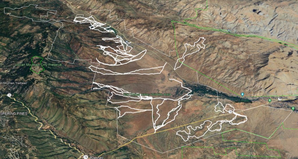
We make extensive plant surveys of the area, often following washes and crossing dense vegetation.
These are some of the routes we have taken.
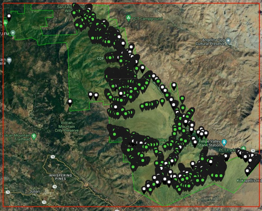
We added a large number of iNaturalist observations, as shown on the map (the green dots are ours).
These observations will eventually end up in the San Diego County Plant Atlas.
At the same time, we take numerous vouchers in the same areas.
Click on the image for an interactive page.
Special finds
There are many plants to choose from, close to 400, but some are more special than others.
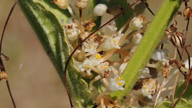
There are only a few records of Cuscuta indecora indecora in San Diego County, here we found one.

Nemacladus pinnatifidus , Comb leaved nemacladus is a rare plant in a wide area, except here where there are sometimes hundreds of larger plants in the drainages.

Over the years we’ve been looking for Prunus fasciculata fasciculata, the Desert Almond, because they are rare in the Anza Borrego Desert and surrounding area.
Except on the south side of 78, which is closed to the public, they are abundant.
References
*1 Kumeyaay Placenames (9 Sept 2022).
*2 Land Management Plan (9 Sept 2022).
*3 San Felipe Valley Wildlife Area (9 Sept 2022).